The Upper Dolpo Trekking takes place in the north-western region of Nepal, one of the most remote and least explored areas of the country. Naturally isolated due to its difficult topography, it still offers a unique opportunity to experience the authentic lifestyle of the local people—almost untouched and unexplored.
Since Dolpo is closely linked to the frontier of Tibet, it is predominantly inhabited by people of Tibetan origin, and their culture remains deeply rooted in Tibetan traditions. Throughout the trek, you’ll encounter people and monasteries that follow the original Tibetan Bon religion, which is much older than Buddhism. Moreover, the trek also provides opportunities to visit several unique monasteries (gompas), including Shey Gompa (the crystal monastery), which remains an important pilgrimage site for many Tibetans.
This trek is long and strenuous, requiring trekkers to be in excellent physical condition and have prior trekking experience. Additionally, Upper Dolpo is a restricted area for foreign tourists, meaning that a special permit is required to travel here.
After you arrive in Kathmandu airport please check our company board outside the main gate there will be our airport representative you will meet with him and he will transferred to hotel by private vehicle. Overnight at Hotel
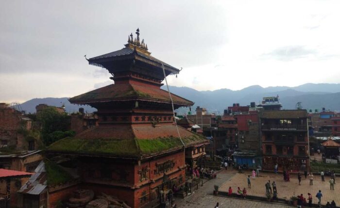
Today after breakfast we start a guided tour to several of the most historical and spiritual attractions in Kathmandu. The day will also be for finalizing official procedure and other necessary arrangements. You will be also briefed on the nature of the trek, equipments and team composition.
Some of landmarks we visit include the World Heritage Sites of Kathmandu Durbar Square, the sacred Hindu temple of PashupatiNath, the famous ‘Monkey Temple’ (Swayambhunath) and Buddhists shrine (Bouddhanath).
In the afternoon, there will be a pre-trip discussion where we can meet our trek leader and other team members. You can also make your last minute buying of personal items as you will be trek to the Himalayas tomorrow.
Today, you can take a breakfast in your hotel and drive to airport then fly to Nepalgunj, about an hour scenic flight brings you to the southern Nepal border with India. This flat land has quite tropical, hot and humid climate. Overnight at Hotel.
After a pleasant it’s take early in morning transfer to airport for the 45 minute flight to Juphal over the Himalayan foothills, with views of Annapurna and Dhaulagiri peaks to the north.
On arriving at Juphal our trekking staff receive you. Our first day adventure begins with an hour downhill walk through the village below the airstrip, then leading through the terraced fields to the Bheri River.
Follow the upstream of Bheri river along the untrafic road to the large suspension bridge. Cross Bheri river, where we enter the Phoksundo River valley. Follow the trail and pass the hospital then it’s a level walk along the Phoksundo Khola to Sulighat. Overnight at Tent Camp.
Cross to the west bank of the river and abandoned settlement of Raktang and trail crosses herders’ hut and horse pastures over the ridge to Jyalhasa a winter settlement of Ringmo village. Keep walking upstream to the east bank at 2460. Sankta.
It’s trail makes some ups and downs through grasses and ferns to a trail junction to Phoksundo lake. The Phoksundo Lake trail climbs over a ridge and a short descend on a rocky path to Chepka.
The trail stays near the river, climbing over a small ridge then, crossing to the west side to avoid a steep ridge. Trail continues upstream climbing ups and downs to the campsite to Renje. Overnight at Tent camp.
After breakfast, our trail climbs over a ridge and descends to a wooden bridge that continues its’ ups and downs along the valley floor an hour to the confluence of Sulighat (known as Phoksundo khola) and Phungmo Khola and eventually brings you a Tibetan village Sumduwa.
In Tibetan, Sum means ‘three’ and Duwa is ‘Trail’. After 5 minutes you will come to a yellow roofed building that looks like Gompa. It’s actually a Tibetan cultural school for Tibetan refugees. This trail eventually leaves the forests and traverses a grassy slope high above the river.
The route switchbacks steeply on a sandy trail through open country, then starts up even steeper gaining over 400 meters ridge at 3730m. Just before the ridge, prayer flags mark a choose up view of spectacular 200 meters high waterfall the highest in Nepal.
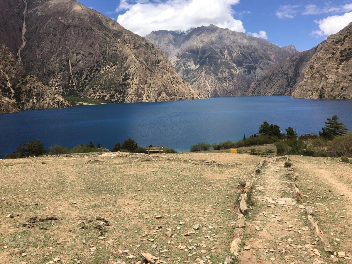
Shortly, afterward you will get first view of Phoksundo Lake. The trail makes a descend through a forest of birch and chir pine to the upper reaches brilliantly clear, rushing water of Phoksundo Khola. Trail climbs gently to the charming village of Ringmo at 3640m.
Trail continues along the Ringmo village to the edge of the village with breathtaking view of Phoksundo Lake and Campsite right on a bank of Lake. Overnight at Tent Camp.
It’s nice to have easy rest day and acclimatization on this elevation. Explore Ringmo village and visit white Thasung Chholing Gompa. The Phoksundo Lake is surreally spectacular. It’s 4.8km long, 108km wide and said to be 650m deep, making it Nepal’s deepest Lake.
It is famed for its intense aquamarine color- a miraculous greenish blue likened to You. If you have more energy, you can walk left bank of the lake upward lake source. Overnight at Tent Camp.
From Phoksundo Lake, adventure continues skirting the shore of the lake as it contours on a rocky ledge along the western bank. This unsteady trail suspended on a gangway of wood supported on pegs driven into crevasse in the rocks, signals the remoteness of the area we are about to enter.
At the westernmost edge of the lake the path leads through a lush meadow that opens up into the flood plain of the Phoksundo Khola. We walk leads through the valley, crossing the river and avoiding the occasional boggy marsh underfoot and coming on bank of river. Overnight at Tent camp.
Today’s our walk leads along the level path through a glacial valley heads to north. At the confluence of Phoksundo Khola and another mountain stream, there is an old wooden bridge. They’re taking to barely distinct path to the north-east of the valley.
There is no trail as such, so it is necessary to climber over the rocks and boulders and to ford a stream that rushes down the steep valley. A long climb brings us to a sheep meadow where the trail veers up a steep ravine.
A hard climb to the top brings to yet another valley where we can see the Kang-La,pass will lead towards Shey Gompa. Overnight at Tent Camp.
Early in morning after breakfast we walk steep climb littered with slate towards the pass. The climb is quite strenuous, especially on the slate screed. From the top of Kang-la 5,160m/16925ft, there are excellent views down upon a large valley which is bisected by a gushing river.
On descending steeply to the valley floor,this path leads a long meandering trek along the banks of the river, crossing and re-crossing it several times. There are mud caves lining the hills overlooking river and we pass through meadows where hairy yaks, hundreds of sheep and domestic mountain goat (Chengra) we found grazing as well near the odd nomadic hut of the herders.
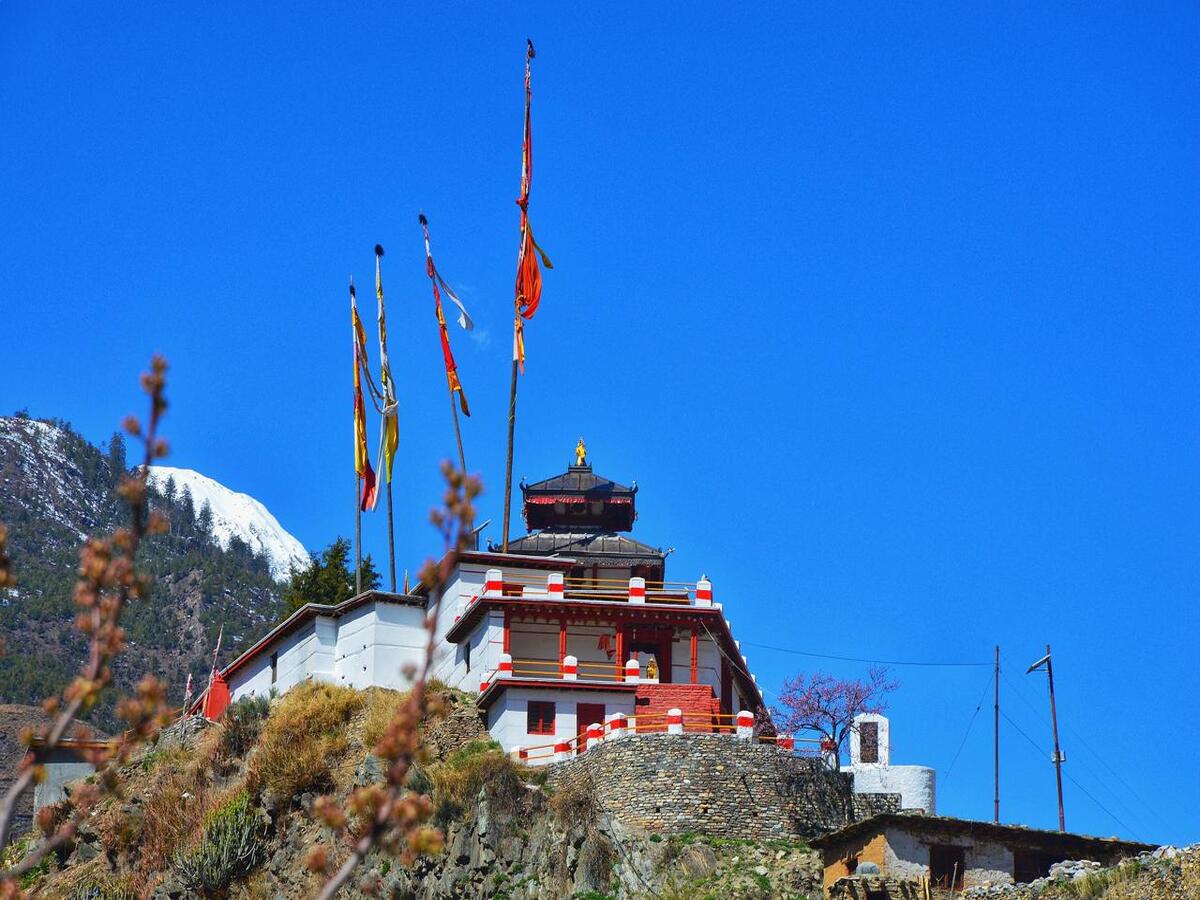
A red chorten heralds our arrival at Shey Gompa 4,390m/14,440ft where a quaint wooden, log bridge leads up to our destination at Shey Gompa compound. Overnight at Tent Camp.
Another well earned acclimatization day for local hike around Shey meaning crystal, this monastery is also known as Crystal Mountain (well described in Peter Matthissen classic novel Snow Leopard). The lama of Shey resides at a red hermitage known as Tsakang gompa which is north of Shey.
It is rather a retreat than a monastery. Tsakang had been a meditation centre of many famous from lamas Tibet. Shey Gompa belong to the Chaiba community, followers of great saint Padmasambhava, known as Guru Ringpoche and Kagyu sects. It was the first Kagyupa monastery and its founder was the lama Tenzing Ra-Pa, built during 11th century.
Shey is famous for its ancient pre-Buddhist culture the Bon Po. In Dolpo the ancient Tibetan way of life combines animism with the teaching of Buddha. Drutup Yeshe first introduced Buddhism in the Dolpo valley. Hundreds of years ago he came to Dolpo encountering a wild people whose supreme God was a’fierce mountain and nature spirit.
Crystal Mountain is east of Shey gompa it is one of the strangest mountain, as its contorted cliffs are laced with quartz and embedded with a rich variety of marine fossils. Shey Gompa stands above the confluence of Kangjunala and Yeju Nala River. Near the confluence there is a group of prayer mills turned by water wheels.
Each year people from all over Dolpo region travel great distances to attend the festival at Shey and to complete the circuit of Crystal Mountain. This is an amazing trip to here certainly makes this trek as special few Westerners have ever ventured up to Shey gompa. Overnight at Tent Camp.
Today we begin follow pleasant trail amidst juniper which descends into a grey, stony canyon. Then the path begins to zig-zag over bare rocks and coarse eroded soil until it eventually brings us to the top of Saldang-la 5,200m/17,056ft.
The subsequent descent towards the north which is long and tiring but we finally come upon the welcome sight of pastures of grazing yaks and sheep, and nomadic tents made from yak hair. This signals our approach to Namgung Gaun at 4,800m/15,744ft. Like Shey, the Namgung monastery of the Karma-pa sect.
The monastery, a red stone structure, is built against the backdrop of a cliff on the north wall of a gorge. The red and white colors of the gimpy and its stupas are the only color in this stark landscape. The village itself consists of only six stone houses and has terraced fields on both sides of the tributary, which flow down to the Nam Khong valley.
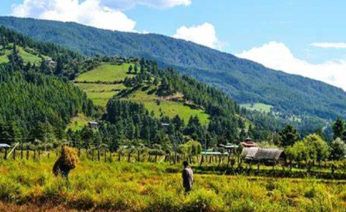
The economy of the region is based on agriculture, animal husbandry and trading. In Dolpo only one crop a year can be grown and this is mainly barley. In some villages buckwheat, oil seed, potato and radish are also cultivated. Recently the main cliff temple collapsed the villagers have now built a beautiful new monastery in the village itself.
Overnight at Tent Camp.
Namduna Gaun our route leads to a climb up a scree slope. Further on it begins a long traverse along some dusty barren mountains. After some hours of hard climb, Saldang 3,620m/ 11,874ft appears below on a plateau high above the Nam Khongmala.
It has a picturesque appearance. Saldang is the largest village of the inner Dolpo area. Though the village lies at about the same altitude as Ringmo it’s totally different then Ringmo, a Himalayan village is situated below the tree line while Saldang belongs to the arid zone of the Trans-Himalayan Tibetan plateau.
The village stretches for nearly two kilometers on an open slope. Saldang consists of five villages having about eighty well built houses with nearly six hundred people. Saldang is a prosperous village not only agriculturally but also for its strategic location on a trade route to Tibet.
After the Chinese invasion of Tibet in 1959, trade with Tibet was virtually stopped. It has been restored to some extent through the barter system by which Tibetan salt reaches mid-Nepal. The Drokpa people from the western plains of Tibet collect salt from the dried lakes north of Tsangpo. Overnight at Tent Camp.
Our journey from diverts further far north to the least unexplored area by westerners any other commercial adventure trekking companies. The trail follows the Nang Chu river most of the way on this wild barren windswept terrain.
Walk begins along the fairly gradual path with few ups and downs slope and then passing through the small settlement of Tiling and Lurigaon till we reach to our overnight camp at Yangze also known as Yangtsher, just before Yangze near Lurigaon.
Here we cross the tributary Panzang river, a short walk from here brings us to an unexplored region of Yangze 4,960m/16,267ft and its very old Bon-Po Monastery for the overnight halt with time for exploration around the villages and the Monastery. Overnight at Tent Camp.
From Yangze there are two trails that connect Sibu (4,560m/14,957ft),long way trail heads due west passing through the very remote villages of Nishalgaon further past Shimengaon. To save time and energy we will retrace path back towards Saldang village which will be much easier and shorter than the other north western route.
From Saldang this trail following the river bed we pass through terraced fields, stupas, chortens, heaps of mani stones with a Chaiba monastery, then passing through the Namdo village which is also prosperous with about sixty houses having nearly 400 inhabitants.
It stretches for more than 5 km on the high slopes to left of Nam Khong Khola. The Namdo monastery is located near the river bed. Our journey continues further down the river for another 2 hours camp near small settlement of Sibu. Overnight at Tent Camp.
Today’s we follow Nam Khong Khola for a while on the morning walk coming across caravan of laden yaks that are on their way towards Tibet border. After days of following the same river, finally we part turning east till we arrive at the confluence of two small tributaries, from here our walk leads to a steep climb to the bottom of Jeng La (4,900m/16,072ft), where we stay for the overnight on a nice meadow. Overnight at Tent Camp.
Early in Morning we walk 2hrs climb towards the top of the Jeng La (5,090m/16,695ft). An excellent view of snow ranges emerges to the south. The north face of the Dhaualgiri massif shines in the morning light. After a wonderful moment here at the pass, our walk leads to descend on rough path towards Tarap valley.
By afternoon we come to the green valley which leads us on the pleasant track down towards Tarap Chu. Tarap is a fascinating valley with vast plains in high mountains. It extends 20km,along the river. Tarap Chu is having ten villages with its cultivated fields and many gompas, chortens of both sects. Visit Tokyu monastery at 4,200m/13,776ft.
This monastery also belongs to the Chaiba sect.The route leads eastward along the downhill course of Tarap Chu in a plain valley with patches of lush verdant grass on both sides of the river which is completely different from other parts of inner Dolpo. There is a marsh which is a common feature in the Desert Mountains of Tibet and the Ladakh Himalaya.
In this valley both Bon Po and Chaiba sects reside together in harmony. After a short trek on this beautiful valley we come to Do Tarap (4,080m/13,382ft). Overnight at Tent Camp.
The name Tarap refers to the entire region. The correct name of the village is Do meaning ‘lower end of the valley’ in Tibetan, but most local people refers to the village as Do Tarap. It consist of several cluster of closely packed some houses and corrals, surrounded by fields of ‘Naked barley’.
The Ribo Bhumpa Gompa above the village was rebuilt in 1955, beside it is unique chorten in a chorten containing the remains of a demon killed by Guru Rinpoche. The painting inside the chorten represents both Bonpo and Nyingma traditions, although the Gompa itself is Nyingma.
The view over the valley is superb. For leisurely half day excursion head east up to the valley to Dero Gompa and Shipchok Gompa a school of Bonpo.Overnight at Tent Camp.
Today’s this moderate walk depending upon the choice of several different campsites so the itinerary can be as flexible as you like. From the quite bare country around Tarap, we descend towards a wide valley which eventually narrows into a gorge.
We walk along the juniper bush and wild rose, typical of dry inner Himalayan valleys, to just above the tree line. On this route we might see herds of blue sheep. By the afternoon time we reach at the confluence of the Tarap Chu and the Lang Khola, a stream that joins with Tarap River from further east.
We will make our camp on a nice meadow, this place is also known as Karmakharka (3,800m/12,464ft), while our porters will perhaps take shelter in a nearby spacious cave. Overnight at Tent Camp.
This morning again continues down the gorge of the Tarap River,alongside it, rising high above on a trail built from the steep slopes might come across people from Dolpo taking their herds to lower pastures for the winter. There are many possible campsites by the river.
This will be one of the exciting days of this trip walk, as the valley becomes so narrow in a deep gorge, some places we can jump from one side to another. Sometimes there is no trace of any path we have to walk across stone slabs fitted on logs in between walls which act as a bridge. The gorge also provides unexpected adventure and thrills.
At some places, the bridges are either damaged or washed away we may be forced to cross the icy torrent on foot. Finally, reaching to the camping spot beside the Tarap khola at Khanigaon (3,150m/10,332ft). Overnight at Tent Camp.
Today we are going to campsite, follows an indistinct village of Lalberi. We pass through an area of impressive forest, before descending into another gorge our walk continue following the river again downstream to reach Tarakot where colourful terraced fields greet us. Tarakot (2,537m/8,321ft) is an old fortress town known by the local people as Dzong, meaning ‘fort’.
Before the Gorkha dynasty Tarakot was the capital. After lunch the walk continues beside the Bheri River in a tremendous gorge with pine trees and an ingenious path built about seven meters above the river. On reaching Dunai (2,030m/6,658ft) after completing the circuit with time for celebration, particularly as bottled beers is available in Dunai. Overnight at Tent Camp.
We retrace the journey back to Jhuphal, which is a short distance walk along the Bheri River to the small airstrip for the last overnight camp of this great memorable adventure. Overnight at Hotel.
Early in morning, it take short scenic flight for 35minutes to Nepalgunj, over the Himalayan foothills overlooking stunning views of the main peaks including Annapurna and Dhaulagiri to the north. On arrival at Nepalgunj depending upon the connecting flight schedule to Kathmandu.
If it is in the afternoon have time for few hours refreshment in the comfort of the Hotel at Nepalgunj. Then connect with the flight back to Kathmandu. Overnight at Hotel.
Today, you have leisure day for relax or shopping in Kathmandu so you can do your own activities by yourself or consult with company to arrange extra activities. Overnight at hotel
After breakfast, End of our services with departure transfer to the Kathmandu airport to board flight for your onward destination.